In many conversations, before we are formally instructed as an Expert Witness or Advisor, we discuss the available data and its suitability.
Just because a file, in any format, contains GPS location data (latitude & longitude) does not mean a detailed, accurate record of a person’s or vehicle’s location is available.
All GPS data records need to include fundamental values to be useful: a GPS location (latitude and longitude). This is essential for showing a point on a map and expressing that location as an address. Generating an address from a latitude and longitude is known as Reverse Geocoding.
GPS alone tells us where someone or something is, but not when. For that, we require a date and time stamp. The date and time associated with a GPS location are very accurate. Still, they are recorded in Coordinated Universal Time, or UTC, but the UK is one hour ahead of UTC/GMT during summer, and therefore, a time calculation must be done of the value depending on the day of the year. It is a simple process that is sometimes missed.
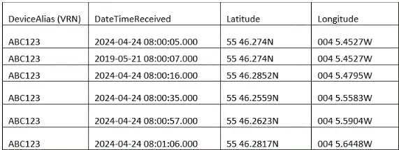
Basic GPS data file
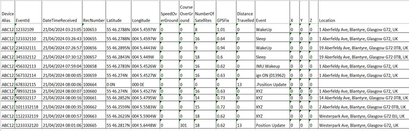
Detailed GPS data File ( additional data values not shown)
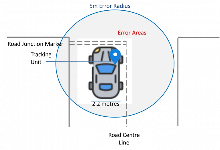
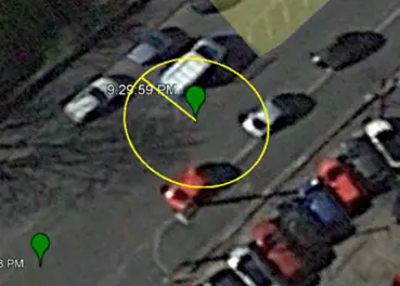
GPS locations also have an accuracy variance. For this discussion, the accuracy is around 5 meters 95% of the time, which is about the length of a car, so it is not an issue in most cases.
However, if the analysis is part of an insurance claim, an accuracy of 5 meters may not be sufficient to place a vehicle on the correct side of the road. To highlight this, we can add a graphical representation of the error margins when displaying location data on a map image.
Information from values such as the Number of Satellites and GPS fix can be used to assess the quality of the GPS receiver’s signal used to calculate a location. Not all systems have this information available in the GPS data files.
Several situations can degrade the accuracy. For example, GPS satellite signals are blocked by buildings and trees, by underground use such as car parks, by poorly installed units or antennas, or by low-cost GPS receivers.
Several methods are used in the data analysis to identify the accuracy of the location data and its suitability for evidential purposes.
Using the data values for the quality of the GPS signal included with detailed GPS data files. This can show if a GPS signal has been lost or is of poor quality.
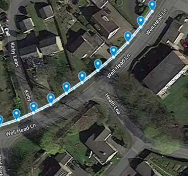
Analysis of GPS locations before and after the places of interest. This allows plotting positions and identifies poor or incorrect GPS locations.
Visual inspection in a mapping system will show locations that are not synced with previous or subsequent locations.
Different Telematics systems and GPS location apps record location data at differing frequencies. This may range from a location record every second to variable-frequency intervals depending on vehicle speed, changes in direction, or sensor-generated records. Examples of sensor-recorded activity are acceleration and deceleration values.
Knowing the criteria for the time intervals between location records will ensure that a detailed analysis is conducted.
Data integrity is critical. It is essential to understand how the data was generated and that it is an original export from the application, not edited or missing data values. Detailed GPS data files contain values such as Event ID or consecutive record numbers, allowing gaps in the data to be identified.
Speed records can be critical in any analysis, especially if the expert is asked to answer questions about a vehicle’s speed up to a collision point. Understanding how speed is calculated, the frequency of updates, and the accuracy of recorded speeds, along with the correct calculations to convert to MPH, all form an essential part of the analysis.
In many cases, calculating an average speed over a defined road journey and comparing it to road speed limits can add context to any opinions formed.
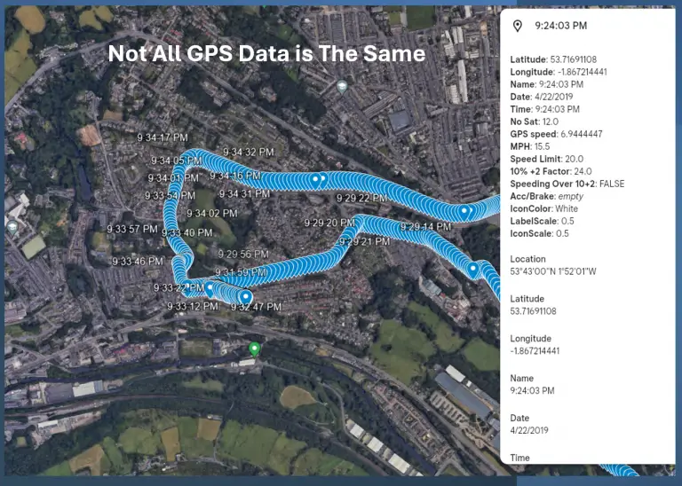
As can be seen, not all GPS data is the same.
The expert witness or expert advisor will bring expertise to the analysis to understand the criteria used to create the location data records, the accuracy levels, the data’s integrity, and the source.