Vehicle ECU Forensic Data Analysis
Onboard Vehicle GPS, Route History and Event Data
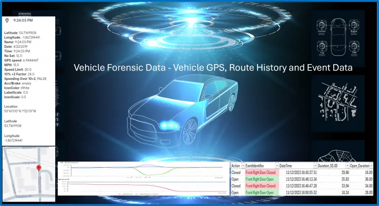
Modern vehicles now contain computers, typically called ECUs, that control functions such as infotainment, Satellite Navigation, SOS emergency call services, driver-assistance systems, airbag control modules, and connectivity with smart devices for voice and messaging. Data from these systems can be analysed to provide valuable information, such as vehicle location and events like ignition on/off, door openings, airbag activations, etc., that can assist in serious crime or collision investigations.
Specialist skills and software are required to extract usable data from these systems. Once available, the data can provide a wealth of information about a vehicle’s history, sometimes dating back to its first manufacture.
Examples of data that can be extracted for analysis include:
- GPS latitude & longitude with date and time stamps.
- Satnav route summaries – Journey start and end locations and times.
- Ignition status.
- Door open/close events.
- Airbag deployment—Date/time and speed. Data records are generally available for the period leading up to the deployment event.
- For crash investigation data, examples include seatbelts, acceleration and braking severity, and impact areas on the vehicle measured by crash sensors.
- Call records if calls are made through the vehicle interface and stored numbers in contact lists.
- Plus, much more usable data.
In many cases, GPS records deleted from satnav systems can be recovered for analysis.
As with telematics, GPS data, onboard location, and event data records can be used to build a full picture of events surrounding a vehicle’s activity, whether for a criminal or insurance investigation.
Once the “raw” data is available, the analysis process is the same as for telematics data from aftermarket tracking hardware. The data is reviewed and then merged into a format suitable for display on a mapping platform. Location data accuracy is verified, and the resulting combined data can then be overlapped onto mapping systems to visually understand specific events.
The data can then be compared with other sources, such as witness statements, CCTV footage, or Cell-Site records.
The combination of multiple data sources provided enhanced analysis opportunities and a greater depth of understanding as to what the “raw” data can tell us.